of Kent Island.
Circumnavigate
Pronunciation: -'na-v&-"gAt
Function: transitive verb
Etymology: Latin circumnavigatus, past participle of circumnavigare to sail around, from circum- + navigare to navigate
Date: 1634
: to go completely around (as the earth) especially by water...
- cir·cum·nav·i·ga·tion /-"na-v&-'gA-sh&n/ noun
(extracted from Merriam-Webster's Collegiate Dictionary)
The word immediately grabs the attention of sailors. It fills one's imagination with visions of tropical island paradises, storms at sea, and everything in between. A person embarking on a circumnavigation is beginning what most certainly will be a great adventure. A captain who has completed a circumnavigation is clearly an accomplished seaman.
Some circumnavigations are more challenging than others. Magellan was the first to circumnavigate the Globe. He accomplished this feat during the years 1519-1522. Joshua Slocum was the first to circumnavigate solo. He sailed his 37 foot sloop, Spray, from Boston on April 24, 1895, and officially ended his trip more than 46,000 miles later at Newport, Rhode Island, on June 27, 1898. Interestingly enough, both these navigators made the trip from east to west - opposite the direction of the prevailing winds.
My brother, Dave, and I didn't consciously planning a circumnavigation when we set out that day although some might argue that we were in denial of our inner thoughts. And who would have been surprised if that proved to be the case? Dave had already crossed all but one of the Great Lakes on his Hobie Cats - most of them solo. Ranging in length from 16 to 21 feet, these cabinless craft provided no protection from the elements. On the contrary, their speed ensured that windchill would be maximized. You might freeze to death on a Hobie, but at least you would freeze quickly.
At our disposal we had a 24 ft. boat with a cabin and four berths - a veritable yacht compared to Dave's Hobies. We had a week of vacation time, a modest supply of provisions, and the Chesapeake Bay. Clearly we were better prepared for extended sailing than Dave had ever been on his Hobies. But truth be told, our plans weren't that grand. We were just going to spend a week exploring the Chesapeake. However, by the time the week was done, we had completed our first circumnavigation...
We had circumnavigated Kent Island.
It was September 13, 1997. I had owned Binary, my Columbia 24, for a little over a year. It had been an eventful year that started with me captaining a keelboat for the first time. It included almost losing the mast and a major boat rebuild. I had become a reasonably proficient captain in that Binary always went where I wanted her to go and we always seemed to make it back afloat and with the same number of crew we had at the beginning of the voyage. I had done a lot of daysailing and anchored out to swim a few times, but I had never done an overnight trip. This was to be the first.
Dave drove down from Cleveland to join me for this great sailing adventure. We arrived in Galesville early in the afternoon. Binary was patiently waiting in her slip behind Pirates Cove. We stowed our gear and finished our provisioning. There was a nice breeze and still quite a bit of daylight left so we decided to go for a sail.
Off we went - down the West River and out onto the Chesapeake Bay. It was a beautiful day and we went with the wind. We worked our way across the Bay and then south towards Bloody Point Light.
Our trip plan was pretty nebulous, but we did know that we wanted to visit St. Michaels. Somewhere into our daysail, we realized that we had already made substantial progress towards St. Michaels and we decided to just keep going rather than return to Galesville.
We passed the lighthouse, rounded the buoy, and turned up into the Eastern Bay. By this time both the wind and light were failing. The chart didn't show any protected anchorages nearby - just a concave portion of coast to the NW.
Night was falling as we approached the shore. I showed my mastery of chart reading by reducing the distance that the shallow water extended out from shore by a factor of 10. The result, of course, was that we ran aground. I had a couple long paddles aboard and Dave and I used them to pole our way back to deep water where we dropped anchor and prepared for our first night on the hook.
The first morning of the trip found us where we had anchored the night before. No storms had blown us away, no boats had run over us in the dark of night, and we had enough water under the keel to be afloat. All in all, a successful anchoring.
We sailed off the hook and began working our way up the Eastern Bay. I had never ventured into the Eastern Bay before, so these were uncharted waters for me in the figurative sense. In the literal sense, I was well prepared with charts. All we had to do was match up what we could see with what was on the chart. This should be easy, right? Well it isn't too tough, but sometimes it's surprising. Distances over the water and distances on the chart aren't always easy to coorelate. For example, the buoys at the north end of Tilghman Point seem much farther offshore than they appear on the chart. On the other hand, the chart made the bridge at Kent Narrows look too far away to see, but it was easily visible.
We rounded the Tilghman Point buoys and headed south down the Eastern Bay. The Eastern Bay is interesting in that it has a shallow area in the middle of the eastern-most leg. This shoal is marked by a bewildering array of navigation aids but once you identify a few markers, you can find your way down either side. This becomes doubly interesting if you are sailing south, because you often have the wind on the nose and you have to tack around the shallows.
Once past the shoal, the Eastern Bay necks down and funnels into the Miles River and St. Michaels lies another mile or two south. It's hard to believe that square-rigged oceangoing sailing vessels were able to make their way through this maze, but they did.
We also made it without incident. I had never been to St. Michaels by land or sea, so I knew nothing about the layout or accomodations. We anchored in the river with the rest of the fleet of pleasure craft and then set out for town on our dinghy.
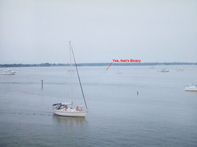
A picture of Binary from the lighthouse.
I should take a moment and explain the dink. I didn't have a dinghy per se, but Dave and I both run whitewater and we had similar kayaks. We used a couple pieces of PVC tubing to tie the kayaks together and form a catamaran. We put covers on the cockpits to keep the waves out and we sat on top of the craft with paddles. This worked quite well except that we had little freeboard, so almost every wave washed over the boats and got out seats wet. It was summer and the weather was warm, so this only dampened our butts and not our enthusiasm, but clearly we needed to revise our strategy for future trips.
We found the dinghy dock in St. Michaels and began exploring the town. The first stop was the Chesapeake Bay Maritime Museum. The museum is a "don't miss" when you are in the area. It's a great mix of boats, artifacts, models, and other exhibits. You can even tour the old screwpile lighthouse that was moved there from Hooper's Strait in 1966. The lighthouse looks out onto the Miles River and provides a grand view of the fleet of pleasure craft anchored there on any summer weekend.
We awoke to another glorious day on the Chesapeake. A nice breeze was blowing and sailing promised to be good. We needed to reprovision before we set sail, but we were on vacation and had no great need to hurry. I made some coffee and we lounged in the cockpit. It was monday morning, so the anchorage was sparsly populated. A waterman worked his way back and forth on a trot line near shore. A woman with a towel wrapped around her ventured out onto the swim platform of a powerboat anchored nearby. She hung up the towel and began showering, wearing only what people usually wear in the shower - nothing. She modestly kept her back to us and we tried not to watch, but it wasn't easy.
If this is what the cruising lifestyle is like, then sign me up!
We motored into town and tied up at one of the marina docks. We paid a few dollars to keep the boat there and then walked into town. We got breakfast and some ice and headed back to the boat. We motored out of the harbor and raised the sails. The wind had eased a bit but the direction was holding so we were able to sail down the Miles and back into the Eastern Bay.
It was early afternoon by now. The day was clear and the sun shown down pretty hot. The wind diminished to near nothing. Binary was barely moving. Dave jumped into the water to cool off. He began swimming next to the boat and despite my best effort, Binary and I couldn't keep up.
Dave finally got tired and climbed back aboard. We were hot, tired, and going nowhere fast. We got out the chart and looked for a place to spend the night. We found a likely looking place that was fairly nearby. It was Shaw Bay, a large cove just into the Wye River. We fired up the iron jenny, lowered the sails, and motored the few miles to Shaw Bay. Little did I know that I was about to discover one of the most popular anchorages on the Bay.
Shaw Bay is a good sized body of water. Most of it has deep water up close to the shore so you have lots of room for anchoring. You can even anchor in a little cove on the far side of the Wye across from the mouth of Shaw Bay, so the shore can protect you no matter which way the wind is blowing. We went well into the Bay and anchored near the narrow spit of land that separates Shaw Bay from the Eastern Bay.
There were very few other boats anchored there and a couple were clearly on permenant moorings. We baited the crab pot and dropped it over the side.
We saw a couple interesting craft come in and dropped anchor on the far side of the Bay. We made them out to be open boats about 20 ft long with a single mast and oars or paddles. They were full of people. We figured they had to be some kind of outdoor education/experience organization out for an afternoon outing.
Dinner time came and went, but the strange boats were still there and they gave no sign of leaving. It didn't seem possible that they would stay for the night. There couldn't possibly be enough room for everyone to sleep on the boats and this was a coed group, what did they do about using the head? We began to think that maybe they were some kind of cult. They were just far enough away that even with binoculars these mysteries would remain unsolved. Maybe it was better that way.
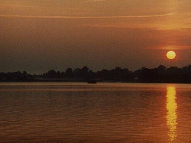
Sunrise on Shaw Bay
There we sat watching the crabbers work their trotlines and the birds dine on the various delicacies that birds dine on and speculating about the "cult" boats across the bay. After a while the birds began heading on down to the next feeding ground. They swam along by ones and twos forming an impressive parade. I had the feeling that this was a daily ritual.
We finally decided it was time to leave Shaw Bay and find new places to explore. Just about that time we noticed that the "cult" boats were beginning to head out. We still had things to stow and the anchor to deal with and sails to raise. By the time we got under way the "culties" were rounding the corner into the Wye. That's the last we saw of them. Who knows where they made off to?
Sailing out of Shaw Bay is can be a challenge. The wind is usually out of the south so it's on the nose as you turn south onto the Wye towards the Eastern Bay. I typically let the motor idle in neutral as I sail out. You have to tack south around the daymark and then get out from shore a bit before you can turn north.
The wind was light as we worked our way north to the buoys at the top of Tilghman Point. We checked the chart to see what interesting places there were to visit. We had fun crabbing the night before, so when we spotted Crab Alley Creek on the chart, we knew we had to check it out. The wind picked up a little as we tacked our way down the western branch of the Eastern Bay. We took frequent sights with the hand bearing compass so we could track our location on the chart and avoid the shallows.
The wind was piping up as we made our way into Crab Alley Bay. We considered sailing back the way we came for a while, but we were new at this exploration mode and so we decided to end our sailing day early and look for a place to anchor for the night. We found the daymarks that led into Crab Alley Creek. They led through a narrow opening and around a bend. We carefully followed them so we wouldn't run aground. The river opened up a little as we passed a marina and then narrowed down again.
Our supply of ice was running low so We circled around by the marina looking for a good place to tie up and promptly ran aground. We wiggled the boat around a bit with the motor and then pulled out the paddles to push off. Binary came free with little effort. We were getting good at this.
We got some ice at the marina and then motored up the river. Crab Alley Creek really isn't much more than a big creek. Houses lined the bank on either side, but they were just far enough from the water that you didn't feel like you were anchored in someone's back yard. We dropped the hook and then baited the crab trap and dropped it overboard. Dave had been messing around trying to catch crabs with a chicken neck on a piece of string and we dropped that over the side, too.
We called our sister on my cell phone to let her know that we had survived the first half of the trip. I talked to her for a few minutes, then I passed the phone over to Dave. I checked the crab line and sure enough, there was a crab hanging on. We didn't have a net and the crab got away before we could get him on board. Dave was still talking when I pulled up the crab trap and there was a crab in it. My sister was getting the play-by-play description and by now thought that all we had to do was drop a line overboard and we would have a crab on it in no time.
We ate some dinner and discussed how to steam the five crabs that we had caught so far. We had a fairly large pot, but nothing to keep the crabs out of the water on the bottom. In a stroke of genius we decided to break our empty beer cans in half and put them on the bottom of the pot. This worked quite well and in no time we had transformed our crabs into an after dinner snack.
This is where the fun really begins. Dave likes simple meals. To him, FOOD = FUEL. Suffice it to say he had never eaten a crab before and I was but a novice at the art. To make matters worse, we started eating the crabs just before sundown. I turned on the cabin lights, but this was our fourth night on the hook and the battery was finally running out of juice. Eventually I got out my headlamp flashlight and we used that to try to see to disect the last couple of crabs.
Once again we were greeted with a beautiful morning. Except for an early morning crabber heading out to set a trot line, our sleep had been undisturbed in this quiet little creek. We ate a little breakfast and eased along between the banks and out into open water. Again we were faced with the question that we asked ourselves almost daily on this and subsequent trips: "Where to next?" We had seen all of the Eastern Bay except the north end and I was intrigued by the drawbridge at Kent Narrows, so off we went.
The breeze was light as we worked our way to the east. Binary has no depth guage and we had already run aground twice, so we kept well clear of the shoal waters at the south end of Kent Island. Finally we turned north towards the narrows. This put the wind behind us and it threatened to turn into another drifter like the day we discovered Shaw Bay. Luckily the breeze held enough to move Binary faster than Dave thought he could swim.
Kent Narrows approached and the highway bridge loomed large ahead. But below it was the old drawbridge blocking the way to sailboats and large powerboats. The bridge opens every half hour during the day and we just missed the 3 PM opening. We fired up the motor and dropped the sails. The wind had increased a bit as it funneled through the narrows. But of greater note was that the tide was changing and the water rushed through the narrows and around the bridge pilings at about 4 knots. We would ride the flow towards the bridge with the engine idling and then rev it up as we turned and fought the current. It was strange to watch the water rushing past the hull and then look up at the shore and see that were were making very little headway against the current.
We did a few laps before the bridge finally went up. Being upstream we got to go first. I spotted the cross current under the bridge right away and steered into it to keep us in the middle of the channel. Even so, it looked like the bridge was awfully close to the mast as we passed under it. We dodged the boats waiting on the north side of the bridge and then pulled up to the gas dock at Mears Point Marina. We tied up and walked up to the office to arrange for a slip. Then it was back to the boat and around to the slip. We tied up and headed for the showers.
We got dinner at one of the local restaurants and then hiked down to a grocery store to pick up a few odds and ends to get us through the rest of the trip.
Our string of beautiful mornings was finally broken. The weather was still relatively warm, but the sky was overcast. It didn't threaten rain, but it was quite a change from the clear, sunny days we had enjoyed up to this point. We bid adieu to Mears Marina and set out for our next adventure of the trip. Navigating the Kent Narrows north channel.
This was one of the few places on the Bay that I had been warned about. The channel had a reputation for being narrow and shoaling. To make matters worse, the channel had been changed, but my charts still showed the old route. We motored out and paid close attention to the navigation marks and the sailboat ahead of us. The channel was actually quite easy to follow and with Binary's 3' 4" draft there was no danger of us bottoming.
Once free of the channel we hoisted sails and again rode the wind. We tacked our way out into the mouth of the Chester River with the object of rounding Love Point at the north end of Kent Island. Soon we were into our game of trying to identify the various navigation aids. Not too far north of Love Point, we were trying to identify a marker when we spotted water breaking in front of us for no apparent reason. A check of the chart showed that we were, indeed, approaching a shoal and we quickly tacked to avoid the shallow water.
The Bay Bridge appears.
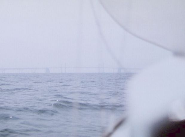
We finally rounded Love Point and made a course for the center span of the Bay Bridge. The bridge is an interesting phenomenon. It doesn't move. This wouldn't seem to be a major discovery, but it's true. It doesn't seem to matter how long or how fast you sail, if you could see the bridge an hour ago, you can still see it now. Conversely, if you couldn't see the bridge an hour ago, you still can't see it now. Not only doesn't the bridge move relative to the eastern and western shores, it never seems to move relative to the north and south horizons. The bridge doesn't sink into or rise out of the horizon so much as it appears or disappears in the blink of an eye.
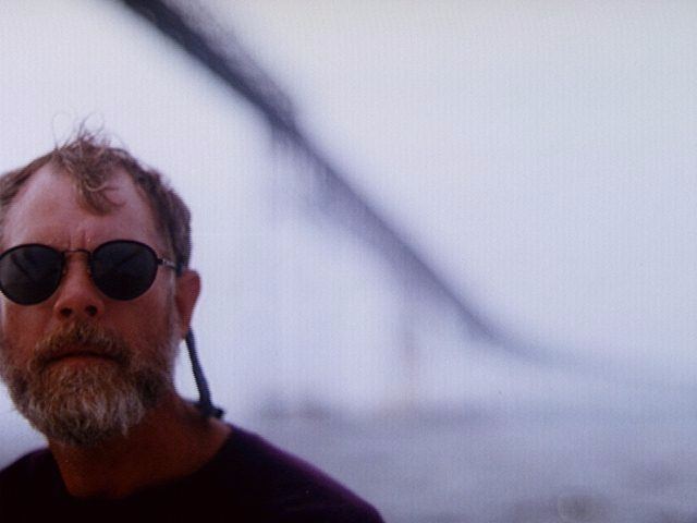
Dave with the Bay Bridge behind him
And so it went. We sailed south towards the main span with the bridge ever in front of us, looming out of the gray water and silhouetted against the sky. Our course would take us into the shipping channel that runs between Baltimore and the center bridge span. Commercial shipping passes through here regularly and it moves deceptivly fast, but just to confuse the matter, ships often anchor below the bridge to wait for a dock in Baltimore. We had to keep a constant watch and be ready to give way should we find ourselves on a collision course with a freighter.
Finally we reached the bridge. The Chesapeake Bay Bridge towers over pleasure craft. You can see the tiny cars and trucks passing way overhead with the sun glinting off their miniature windows. I don't think you are ever quite prepared for just how tall the bridge stands. The second surprise comes when you start to pass under the span and look ahead and realize that there are two bridges, one eastbound and one westbound. Most of the time that you spend passing the bridge is not spent under it, but rather between the two spans.
In contrast to the eternal approach and departure, the Bay Bridge passage seems very quick. One moment you are approaching the first span and the next moment you are leaving the second. The only time the transit takes any appreciable time is when you are sharing the channel with commercial ships. Then it takes on its own life as the wind accelerates through between the pilings and the waves bounce between the footers and the ships, tossing even large yachts rather rudely.
Then you are through.
That day the bridge was like the gateway to another world. The overcast sky began to give way to the sun, who in turn brightened the sea and the sky and washed the oily look from the waves leaving them sparkeling all around. We trimmed the sails and pointed Binary towards the Severn River and the sailing Mecca of the East - Annapolis.
Some say Annapolis is the sailing capitol of the country and perhaps even the world. There are those in Newport and San Deigo and Auckland and probably a dozen other ports around the globe who would dispute that claim, but they would be hard pressed to prove their cases. There is always a sailboat moving on the Severn and it is more likely to be under sail than power. And chances are that if you see one sailboat, you see two, and if you see two they are probably racing. But it's even more common to see three or more sailboats at any given time and they are undoubtedly engaged in a heated one-design class battle.
New York may be the city that never sleeps, but Annapolis is the town where you can only sleep when you are not on watch. And right across the Spa Creek bridge is (The Maritime Republic of) Eastport, a drinking town with a sailing problem. This is the town where the end of winter is marked by the ritual burning of the sailors' socks.
The downside to all the boat traffic is that the water is constantly chopped up. We cruised up the Severn bobbing along like a rubber duck in a bathtub.
We threaded our way through the oncoming boats of all the folks who had snuck out early for an afternoon's sail. The course is easy: just head for the US Naval Acadamy. We dropped the hook off the Naval Acadamy wall, cleaned up a little and caught a water taxi into town.
After the quiet creeks and bays we had anchored in during our voyage, it seemed strange to walk the busy streets of downtown Annapolis. It's a quaint old town full of modern people. Walking down the hill towards the water one can almost picture the squared-rigged sailing vessels tied up to the pier with horse-drawn carts waiting to be loaded for transport to market.
Today would be the final leg of our journey. We had breakfast and were under way by 9:30 AM. We bid farewell to Annapolis and eased down the Severn under light wind. Once past Tolly Point the wind picked up. Binary was clearly in here element now as she cut cleanly through the water.
We tacked across the Bay and then back towards Thomas Point Light. We found ourselves about to pass through one of the ever-present Annapolis area races, so we tacked away across the Bay. Once clear we tacked back across the Bay and into the West River. We were back in the slip by 3 PM.
After 6 days, 22 hours and 23 minutes we had completed our "circumnavigation".
Eric White